
Portrush is on the north Antrim coast of Ulster, close to the county Derry border. It was originally a small fishing village built around the port, on a peninsula. The town was recorded as having been granted to Richard de Burgo in 1305. There are many spellings of the name of the town – Portros, Portross, Portrossce – all meaning Port on the headland.
Shortly after the ice age, some ten thousand years ago, the headland was an island surrounded by bog land. Evidence of the bog can at times be found exposed on the West Strand. Evidence of early settlements have been found where the East Strand car park and Causeway Street are now situated.
Above the Harbour next to Ramore head there used to stand the taller Crannagh Hill but it was quarried away to provide the rock to create the harbour’s pier. Also around here used to stand a castle known as Castle an Teenie (Castle of Fire), because a light was shone from it on stormy nights to warn sailors of the rocks all around.

The village of Glenmanus, where I spent my first five years, is less than a mile from Portrush harbour, and just off the road to Coleraine. Originally Glenmanus would have consisted of a small cluster of houses, surrounded by farm land. When I was young, Glenmanus was on the edge of Portrush, but today it has been swallowed up by the expansion of the town and the old traditional Irish houses have been demolished and replaced by humdrum modern bungalows.
Portrush remained little more than a fishing village, until the railway between Belfast and Londonderry, via Coleraine, was completed in 1855, with a branch line connecting the latter to Portrush. With easy access from the industrial cities, Portrush was eventually transformed into a fashionable seaside resort, complete with hotels, boarding houses, golf course, boating, cinemas, amusement arcades, bowling green, tennis courts etc.
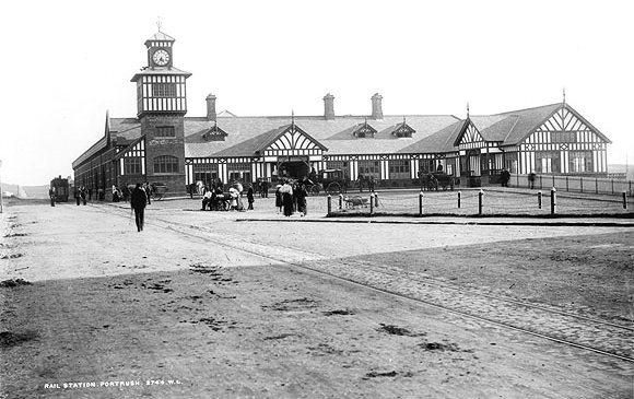
In 1870 the Belfast and Northern Counties Railway purchased the already established Antrim Arms Hotel and renamed it as the Northern Counties Hotel in 1883. With over 100 rooms overlooking the Atlantic, both at the front and back, it provided luxury accommodation for wealthy tourists visiting the Giant’s Causeway. It even had an indoor swimming pool in an era when few, if any, existed within many miles For many years in the late 1940s and 1950s, my father’s dance band played at night in the ballroom during the summer season, as well as the Easter and Christmas holidays, often with an additional session in the afternoon.

An ancient abbey formerly stood on the site of the hotel and its lawn. It was mentioned in a document from 1262. In 1884 portions of the walls were unearthed, with quantities of human bones.
The hotel was destroyed by arson in 1990 and the owner and two others were eventually charged with paying terrorists to burn it down, in order to claim the insurance money. The owner was Roy Crawford, with whom I used to work at Dalzell & Campbell in Coleraine.
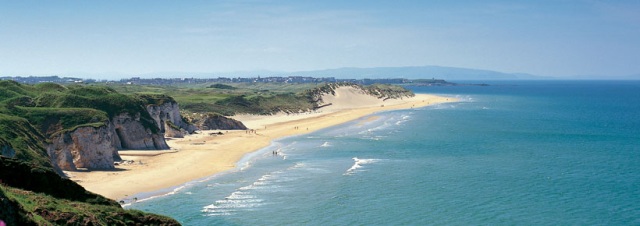
East Strand lies between Portrush and the White Rocks. In calm weather the water looks inviting, but it is both very cold and dangerous, with strong currents and steeply shelving shore. Behind the East Strand lies an extensive area of sand dunes.

About halfway along the strand there is a deep hollow in the sand dunes, between the Strand and the golf course. Here it is believed took place the Battle of the War Hollow in 1103, in which the King of Norway, Magnus Barefoot, was killed along with many of his supporters.

At the eastern strand are the White Rocks, an area of chalk cliffs, with caves, arches and freestanding pillars.
North of the East Strand, between one and four kilometres off shore, are the Skerries, a group of seventeen islets which help create a natural breakwater. There is vegetation on four of them. The islet furthest east is called Island Dubh. It is probable that it was named after Tavish Dubh, a pirate, who once frequented the Skerries, and died in his ship there, and was buried on the island. The place of his grave is unknown. It is said that Tavish Dubh, in 1310, when Edward Bruce invaded North Antrim with the object of winning Ulster, waylaid four English ships bound with provisions for Coleraine, held by an English army, and took their provisions up the river Bann to Bruce, who was in sore straits. Soon after, Bruce abandoned his attempt.

On the east side of the largest of these islands there is good shelter, with an anchorage of six fathoms, a place often made use of in later times by smugglers.
In my time, there was a boat that took occasional visitors around the islands, when the sea was relatively placid, but I personally never knew anybody who had ever set a foot on them.
For most of us, they were so near, yet so far away…
